| HOMEAREA ATTRACTIONS | OUTDOORS | EVENTS | COMMUNITY | PHOTO GALLERY | BUSINESSES |

Libby Montana News Archive

LibbyMt.com > News > August 2010 > Geiger lakes, Carney Peak and Lost Buck Pass hike


Upper Geiger Lake. Photo by Bob Hosea.
Upper Geiger Lake
View of Upper Geiger Lake with Lost Buck Pass in the background.

View of Geiger Lakes. Photo by Bob Hosea.
View of Geiger Lakes
View from Carney Face of Geiger Lakes and Lost Buck Pass.

Wanless Lake. Photo by Bob Hosea.
Wanless Lake
Wanless Lake from Lost Buck Pass.

Upper Geiger Lake. Photo by Bob Hosea.
Upper Geiger Lake
Upper Geiger Lake with Carney Peak in the background.

Spruce Grouse and chick. Photo by Bob Hosea.
Spruce Grouse and chick

On the Trail. Photo by Bob Hosea.
On the Trail
Geiger lakes, Carney Peak and Lost Buck Pass hike
Trail report by Bob Hosea
by LibbyMT.com
August 23, 2010

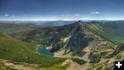
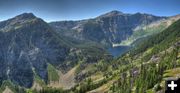
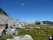
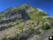
Bob Hosea took another trip to Geiger Lakes in the Cabinet Mountains recently. Even though he did this hike earlier in the year, he wanted to go back up to redo the photos from Lost Buck Pass. "Last September when I was at Lost Buck Pass there was a lot of smoke in the area from fires and the pictures were very hazy. " He also wanted to climb up on Carney Peak so he could get pictures of the lake from a different angle.

Bob usually takes his video camera along and posts a video of each hike on YouTube. His camera decided to take a swim in Fish Lakes on one of his earlier hikes, so he has been trying to get that working again. He took a video of this hike anyway, apologizing for some spots that appear under certain lighting conditions, and it is posted at this link: http://www.youtube.com/watch?v=BcVV0M2MQbs

Bob welcomes comments and questions from people about area hikes. He can be reached by e-mail at: hiking@thebobfactor.com

Here is Bob’s August Geiger Lake hike trail report:
=================================================

To get to the trailhead for Geiger lakes #656, turn onto the West Fisher Creek road #231 from Highway #2, which is about 26 miles east of Libby. Drive about 6 miles and then turn left onto the Lake Creek campground road, and then go about 1/2 mile and turn left onto the Geiger Lakes trail road.

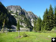
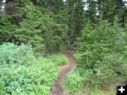
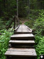
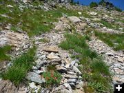
The trail is in great shape from start to finish. There are many people using this trail and I saw a total of 8 people during my hike. There were a lot of bugs out, but I didn't have any problems with biting flies or mosquitoes.

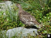
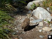
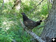
Near the lakes there were still many huckleberries and I did see one adult bear near the upper lake that was feeding on the berries. The bear was two-toned brown in color. I also saw many Spruce grouse going in and coming out. I can see why the Spruce grouse has the nickname "fool hen"; because you almost end up stepping on them trying to get past them. They don't have any fear of humans.

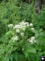
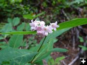
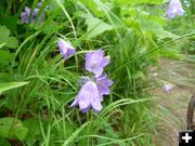
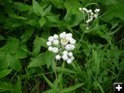
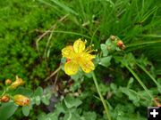
I saw many wildflowers along the trail which included Indian Paintbrushes, Pearly Everlasting, Alpine Harebell, Purple Aster, Bird's Foot Trefoils, Cow-Parsnip, Dogbane, St. John's-wort and pink Spirea.

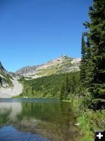
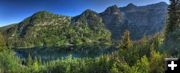
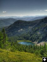
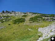
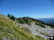
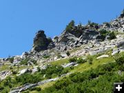
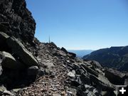
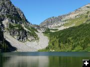
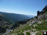
Seeing Geiger lakes is well worth the trip all by itself. The upper lake is just a little over 3 miles, in trail distance, with a 1700 foot elevation gain. From the upper lake you have a great view of Carney Peak and Lost Buck Pass. And, if you go the extra mile to Lost Buck Pass will you will be given the awesome view of Swamp Creek drainage, Buck lake, Wanless lake and Engle Peak. Something that's well worth the extra mile.


Related Links
  • Hike to Northwest Peak Lookout - – July 28, 2010 (36 photos)
  • Little Spar Lake hike - - July 16, 2010 (30 photos)
  • Granite Lake hike - - June 27, 2010 (37 photos)
  • Bramlet Lake hike - - June 16, 2010 (22 photos)
  • Cedar Lakes hike - June 9, 2010 (25 photos)
  • Rock Lake hike - - May 17, 2010 (18 pictures)
  • Lower Geiger Lake hike - - May 9, 2010 (14 pictures)
  • Leigh Lake hike - - April 28, 2010 (7 photos)
  • Rock and Leigh Lake Trek - - August 31, 2009 (11 pictures)

  • The Bob Factor - - Bob's website

  • Lower Geiger Lake. Photo by Bob Hosea.
    Lower Geiger Lake

    Carney Pass. Photo by Bob Hosea.
    Carney Pass

    Upper Geiger Lake. Photo by Bob Hosea.
    Upper Geiger Lake

    Carney Peak. Photo by Bob Hosea.
    Carney Peak

    Foot bridge. Photo by Bob Hosea.
    Foot bridge
    Foot bridge at the start of the trail.

    Cow Parsnip. Photo by Bob Hosea.
    Cow Parsnip

    Dogbane. Photo by Bob Hosea.
    Dogbane

    Harebell. Photo by Bob Hosea.
    Harebell

    Female Spruce Grouse. Photo by Bob Hosea.
    Female Spruce Grouse

    Spruce Grouse chick. Photo by Bob Hosea.
    Spruce Grouse chick

    On the trail. Photo by Bob Hosea.
    On the trail

    Pearly Everlasting. Photo by Bob Hosea.
    Pearly Everlasting

    St. Johns Wort. Photo by Bob Hosea.
    St. Johns Wort

    Heading up Carney Face. Photo by Bob Hosea.
    Heading up Carney Face

    Carney Face. Photo by Bob Hosea.
    Carney Face

    Looking towards Carney Pass. Photo by Bob Hosea.
    Looking towards Carney Pass

    Ridge along Carney Face. Photo by Bob Hosea.
    Ridge along Carney Face

    Lost Buck Pass trail. Photo by Bob Hosea.
    Lost Buck Pass trail
    Trail through Lost Buck Pass.

    Upper Geiger Lake. Photo by Bob Hosea.
    Upper Geiger Lake

    View of Lost Buck Pass. Photo by Bob Hosea.
    View of Lost Buck Pass
    View from Carney Face.

    Ridge. Photo by Bob Hosea.
    Ridge
    Ridge top along Carney Face.

    Male spruce grouse. Photo by Bob Hosea.
    Male spruce grouse

    RIP. Photo by Bob Hosea.
    RIP
    RIP trail marker between the lakes.

    Wilderness sign. Photo by Bob Hosea.
    Wilderness sign

    LibbyMt.com > News > August 2010 > Geiger lakes, Carney Peak and Lost Buck Pass hike
    | HOMEAREA ATTRACTIONS | OUTDOORS | EVENTS | COMMUNITY | PHOTO GALLERY | BUSINESSES |
    All page content copyright 2010. All rights reserved. May not be used without permission.

    home page
    LibbyMT.com
    PO Box 940, Libby, MT 59923
    406-293-3608
    e-mail: info@libbymt.com