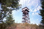
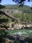
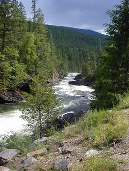
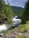
Kootenai
River (Click here for
more
information)
This blue-ribbon
fishing stream has trout and many other species of fish including white
sturgeon which can live to be 80 years old and over 6 feet in length.
The river's water flows from Canada into Lake Koocanusa, its waters held
back in a 90-mile reservoir by the Libby Dam
20 northeast of Libby. The 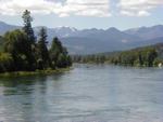 town
of Libby is nestled in the Libby Valley along the shores of the Kootenai
River. Past Kootenai Falls, the river
flows past the town of Troy, and then heads back into Canada, reentering
the United States in Washington, where it flows into the Columbia River
and on to the Pacific Ocean. This river is popular for fishing, river
floating, rafting, and even summer inner-tubing. Water levels can fluctuate
during the summer depending on the volume released by the US Army Corps
of Engineers from Libby Dam. town
of Libby is nestled in the Libby Valley along the shores of the Kootenai
River. Past Kootenai Falls, the river
flows past the town of Troy, and then heads back into Canada, reentering
the United States in Washington, where it flows into the Columbia River
and on to the Pacific Ocean. This river is popular for fishing, river
floating, rafting, and even summer inner-tubing. Water levels can fluctuate
during the summer depending on the volume released by the US Army Corps
of Engineers from Libby Dam.
Lake
Koocanusa (Click here
for
more information)
This 90-mile
long reservoir behind Libby Dam is a recreational
delight. 50 miles of this reservoir lie in the United States and the
other 40 are in Canada. The name is a combination of KOOtenai-CANada-USA,
the winning entry of a lake-naming contest as part of the Libby Dam
construction project in the 1970s. The roads on either side of the lake
make a wonderful driving loop with beautiful views of both sides of
the lake. This loop through the forest along State Hwy 37 and the Forest
Development Road (FDR) 228 was designated a Scenic ByWay in 1992. There
are many turnouts along the roads with great views of the lakes. Campgrounds
and boat docks are located on both sides of the lake, accommodating
both tent and RV campers. Bring your camera, because wildlife is often
seen along these roads. Deer, moose, elk and bear are often seen along
the sides of the road. The Ural-Tweed bighorn sheep herd are often seen
on the eastern side of the reservoir on the rocky cliffs (and sometimes
beside the road).
The Libby
Dam site has a day use area and a boat dock. Tours of the dam are
given during the summer. Those wishing to use boat facilites at the
marinas early in the spring should call ahead to the US Army Corps of
Engineers to check the water level of the lake, which is often lowered
to make room for spring snow melt-off.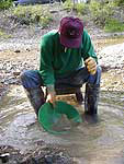
Libby
Creek Gold Panning Area (Click here for More
Info)
The Libby
Creek Recreational Gold Panning Area is located 23 miles south of Libby,
Montana, within the Kootenai National Forest. The public is allowed to
pan for gold within this area and any gold you happen to find is yours
to keep. Some rules do apply, but this is a great recreational opportunity
for the whole family.
Libby
Dam (Click here for More Info)
The Libby
Dam was completed in 1972 as a joint project between the United States
and Canada in an 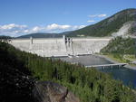 effort
to provide flood protection and to generate hydroelectric power. The
422 foot tall Libby Dam holds back 90 miles of water in the Lake Koocanusa
reservoir. 48 miles of the reservoir lie within U.S. borders, the other
42 miles are in Canada. Lake Koocanusa
area offers many recreational opportunities for fishing and boating.
There are campgrounds, picnic
facilities, marinas and hiking trails in many places along both sides
of the reservoir. effort
to provide flood protection and to generate hydroelectric power. The
422 foot tall Libby Dam holds back 90 miles of water in the Lake Koocanusa
reservoir. 48 miles of the reservoir lie within U.S. borders, the other
42 miles are in Canada. Lake Koocanusa
area offers many recreational opportunities for fishing and boating.
There are campgrounds, picnic
facilities, marinas and hiking trails in many places along both sides
of the reservoir.
Northwest
Peaks Scenic Area (Click here for More
Info)
19,100
acre Northwest Peaks Scenic Area, part of the Kootenai National Forest,
is located in the northwest corner of Montana close to both the Canadian
and Idaho borders. The Northwest Peak Trail 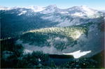 offers
scenic views of the upper West Fork Yaak River drainage and a panoramic
view of the surrounding area at its crest with primitive recreational
opportunities. Part of the Selkirk Range, the area contains alpine forests,
lakes and rocky mountain peaks with elevations that reach to heights
of more than 7,700 feet. The Forest Service cautions that the trail
and unpredictable weather at high elevations limit access during early
and late season. offers
scenic views of the upper West Fork Yaak River drainage and a panoramic
view of the surrounding area at its crest with primitive recreational
opportunities. Part of the Selkirk Range, the area contains alpine forests,
lakes and rocky mountain peaks with elevations that reach to heights
of more than 7,700 feet. The Forest Service cautions that the trail
and unpredictable weather at high elevations limit access during early
and late season.
Ross
Creek Cedars (Click here for More
Info)
This old
grove of western red cedar trees is located not far from Bull Lake, in
a valley on the western side of the Cabinet Mountains. These tall trees
loom some 175 feet above Ross Creek. Local loggers discovered the grove
and then worked to protect it. In 1960 the U.S. Forest Service set aside
the Ross Creek Cedar Grove and it is now designated a scenic area. Today
there is an informative nature trail through the grove with interpretive
signs about ecology and the area's history. Near the trailhead are handicapped
accessible toilets and a picnic area. The self-guided walk through the
grove takes approximately an hour and a half. The turn-off to Ross Creek
Cedars is 1/2 mile past the south end of Bull Lake on Montana Hwy. 56 (Bull
Lake Road).
Scenic
ByWay-Lake Koocanusa
The 67-mile
long Lake Koocanusa Scenic ByWay follows the Kootenai River and Lake
Koocanusa along State Highway 37 connecting Libby and Eureka. This
road is open year-round offering vistas of the river and lake. The ByWay
also includes a side loop along FDR Road No 228 around the west side
of the lake. This is a leisurely, two-lane, paved road that is closed
in the winter. The scenic ByWay highlights the southern half of Koocanusa
Reservoir. Wildlife is frequently seen along the way, especially in
the morning and evening hours. Deer, moose, elk, bear, eagles and osprey
live in the forest along the way. Rock outcrops and ledges along the
road provide habitat for bighorn sheep. Visitors can stop by the Libby
Dam and take in a tour, or picnic in one of the numerous primitive
sites or campgrounds along the way.
Ten
Lakes Scenic Area (Click here for More
Info)
Ten Lakes
Scenic Area is one of the original nine areas designated for special wilderness
evaluation under the Montana Wilderness Study Act. With the Canadian border
as one of its boundaries, the Ten Lakes Scenic Area is located along the
northeastern edge of the Kootenai National Forest dominated by a high ridge
of the Whitefish Mountains. Long ago, alpine glaciers shaped much of this
country. This 15,700 acre rugged wilderness area is dominated by deep carved
valleys and high rim-rocked basins with numerous lakes. Mountains in the
wilderness area rise to an elevation of more than 7,800 feet. Forested
areas contain Englemann spruce, subalpine fir, lodgepole pine, Douglas
fir, white bark pine and alpine larch. Wildflowers are abundant in spring
and summer, and ripe huckleberries are backpacker's delight. Several trails
criss-cross the area and are accessed from Highway 93 via various Forest
roads.
Turner
Mountain Ski Area (Click here for More Info)
22 miles
from Libby up the Pipe Creek Road, Turner Mountain Ski Area offers downhill
skiing with 2,400 feet of vertical rise. Turner sits at 5,952 feet elevation
and operates with a 5,600 foot Double Chairlift. Facilities include: Day Lodge
with Snack Bar, Ski Rentals. Ski Patrol on duty. Open Friday through Sunday,
Holidays, daily Christmas to New Years. Also available by reservation.
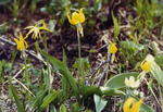 Wildflowers Wildflowers
Wildflowers
bloom throughout the summer and include lupine, arrowleaf balsamroot, beargrass,
violets, trillium, columbine, Indian paintbrush, fairy slipper orchids,
sego lilly, buttercups, phlox, harebell and many others. See our photo
gallery for pictures!
Wildlife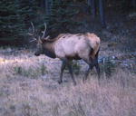
The area
is home to many species of wildlife including whitetail and mule deer,
elk, moose, black & grizzly bear and mountain lion. The large Clark
Fork elk herd on the Cabinet District of the Kootenai Forest has obtained
statewide prominence. Mountain goats and bighorn sheep live in on the
rocky cliffs of the Wilderness areas, Kootenai River Gorge and Lake
Koocanusa drainages.
 Yaak
Falls Yaak
Falls
Located between Troy and Yaak, Montana, these scenic falls cascade in
a beautiful narrow mountain valley, a photographer's delight. The sparsely
populated Yaak area is rich in history and offers many recreational
opportunities away from the crowds. A scenic turnout allows easy viewing
of the falls.
More
Area Attractions Information from KooteNet
|
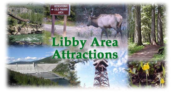
 The
Libby area is offers over 2 million acres of public lands for the outdoor
recreationist. The Kootenai National Forest has hundreds of miles of hiking
trails and many scenic places to camp with wildflowers and huckleberries
nearby. High mountain lakes, miles of streams, and the Kootenai River beckon
the angler. 90-mile long
Lake Koocanusa is a major attraction to boaters and lake fishermen.
The
Libby area is offers over 2 million acres of public lands for the outdoor
recreationist. The Kootenai National Forest has hundreds of miles of hiking
trails and many scenic places to camp with wildflowers and huckleberries
nearby. High mountain lakes, miles of streams, and the Kootenai River beckon
the angler. 90-mile long
Lake Koocanusa is a major attraction to boaters and lake fishermen.
 town
of Libby is nestled in the Libby Valley along the shores of the Kootenai
River. Past Kootenai Falls, the river
flows past the town of Troy, and then heads back into Canada, reentering
the United States in Washington, where it flows into the Columbia River
and on to the Pacific Ocean. This river is popular for fishing, river
floating, rafting, and even summer inner-tubing. Water levels can fluctuate
during the summer depending on the volume released by the US Army Corps
of Engineers from Libby Dam.
town
of Libby is nestled in the Libby Valley along the shores of the Kootenai
River. Past Kootenai Falls, the river
flows past the town of Troy, and then heads back into Canada, reentering
the United States in Washington, where it flows into the Columbia River
and on to the Pacific Ocean. This river is popular for fishing, river
floating, rafting, and even summer inner-tubing. Water levels can fluctuate
during the summer depending on the volume released by the US Army Corps
of Engineers from Libby Dam.