| Trail
Name & Info |
Trail
Description |
Directions
to Trailhead |
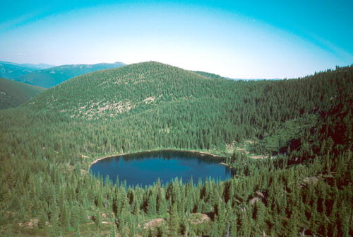
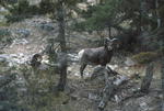
Alexander
Mountain Trail #270
Length: 3.5 miles
West of Libby Dam &
Koocanusa Reservoir
Trail Beginning: Road 228
Elevation: 2,830 feet
Trail End: Fleetwood Point
Elevation: 4,682 feet |
This trail offers
a scenic overlook of Lake Koocanusa after 1/2 mile on the trail and is
suitable for a short hike to the overlook or for a more rugged day hike.
No restrooms or stock facilities are available. |
From Libby, go
northeast 12 miles on Highway 37. Turn left onto FDR 228 and travel for
approximately 5 miles to the trailhead, before reaching Libby Dam. There
is adequate parking at the trailhead for several vehicles. Paved road access. |
Baree Creek
Trail #489
Length: 1.5 miles
Southern end of Cabinet
Mountain Wilderness area, east side of range
Trail Beginning: Silver Butte
Road, Wilderness boundary
Elevation: 3,800 feet
Trail End: Cabinet Divide
Trail 360; Elevation: 6,000 feet |
Trail 489 passes
the Baree Lake access trail at about 3.0 miles, and continues to the divide
as the first portion of the popular Baree-Bear Lakes Loop. Use of the old
cabin east of the lake is prohibited. During late July and August there
is good huckleberry picking in this area. This trail is also used for ski
touring in the winter months. This trail is within designated wilderness
area, thus no motorized vehicles are permitted on this trail or within
the wilderness boundary. (This applies to mountain bikes too.) |
28 miles south
Libby on US 2. Turn right onto Silver Butte Road 148 and continue 10 miles
to the trailhead. Turn right at the trail sign and drive under the power
line. Paved highway, then gravel and dirt road access.

|
Barren Peak
Trail #6
Length: 8.0 miles
South of Libby appx. 30
miles
Trail Beginning: Road 231
Elevation: 2,900 feet
Trail End: Trail 6, continues
to Porcupine Mountain and beyond
Elevation: 5,000 feet. |
The center 3
miles of the trail are in open
parks and offer excellent
views of the South Cabinet mountains. Barren Lookout may be considered
a destination from either end of the trail.
|
25 miles south
of Libby on Highway 2. Turn right onto the Libby West Fisher Road. The
first access is approximately 1 mile up this road, signed on the right,
and begins immediately across the creek. The second access is 4.25 miles
off US 2 on the same road and signed on the left. Paved highway, then gravel
road access. |
Bear Creek
Ski Trail
Length: 3.5 miles total
South of Libby appx. 8 miles.
Trail Beginning: Bear Creek
parking area
Elevation: 2,800 feet
Trail End: Loop, Bear Creek
parking area |
This course consists
of an easy, moderate, and difficult connecting loops, great for the beginner
to the advanced. On a clear day these trails offer a spectacular view of
the Cabinet Mountains.
|
7.5 miles south
of Libby on US 2. Turn right onto Bear Creek Road 278 and travel
1/2 mile to parking area on left. Paved highway, then gravel road access. |
Bear Creek
Snowmobile
Length: 11 miles
Appx. 10 miles south of
Libby
Trail Beginning: 2.5 miles
on Road 278
Elevation: 2,800 feet
Trail End: End of road 278
Elevation: 4,000 feet |
This is an easy
11-mile, one-way route which sidehills along the Big Cherry Creek valley
bottom. On a clear winter day, this trip offers a spectacular view of the
Cabinet Mountains. The snowmobiler can bear west before the bridge and
continue on for another 3 miles to an outstanding cathedral-type dead end.
Cable Creek road also branches off to the left approximately 2 miles before
the end of Bear Creek road. |
7.5 miles south
of Libby on US 2. Turn right onto Bear Creek Road 278 and travel about
2.5 miles to where the snowplowing ends. This is adjacent to a private
ranch where a small parking and turnaround area is located. No unloading
ramp is available. Paved road then gravel road access. |
Bear Lakes
Trail #531
Length: 3.0 miles
South of Libby appx. 40
miles, southern end of the Cabinet Mtns
Trail Beginning: Trailhead
Elevation: 3,700 feet
Trail End: Junction
with Trail 63; Elevation: 5,900 feet |
The trails climbs
steadily to near the top of a ridge. The access trail to Little Bear Lake
is .3 mile before the junction. Middle Bear and Big Bear Lakes are reached
by taking a right turn at the junction. A trail leads to the middle lake,
and the big lake is reached by a short bushwack further to the north. The
Bear Lakes Trail is a portion of the Baree-Bear Loop and are within the
Cabinet Wilderness Area. No motorized vehicles are permitted on this trail
or within the wilderness boundary (including mountain bikes). On the Cabinet
Mountains Wilderness Map this trail is designated as Trail 178. |
28 miles south
of Libby on US 2. Turn right onto Silver Butte Road 148 and travel approximately
9 miles to the trail sign. Turn right and continue .1 mile under
the power line. Ample parking is available at the trailhead. Paved road,
then gravel road access. |
Bighorn Trail
#120
Length: 4.5 miles
West of Libby following
north side of Kootenai River appx. 7 miles.
Trail Beginning: End of Kootenai
River Road
Elevation: 2,100 feet
Trail End: Kootenai River
and sidehill |
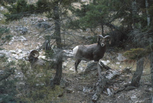
This pre/historic
trail follows the river through old orchards and bighorn sheep ranges.
Eagles, osprey, river otters, and Harlequin ducks may be seen as well as
an abundance of wildlife. This is a very popular trail and benches are
located throughout the course. Fishing along the river is excellent. |
From Libby, turn
off Highway 37 onto Kootenai River Road just over the Kootenai River Bridge.
Follow for approximately 7 miles to the trailhead at the end of the road.
Paved road access.
|
Blacktail
Trail #536
Length: 5.0 miles
South of Libby appx. 35
miles
Trail Beginning: Trail 293
Elevation: 3,580 feet
Trail End: Trail 343
Elevation: 5,560 feet |
This trail climbs
steeply for the first 3 miles to the ridgetop, hiking then becomes easier
and scenic vistas can be enjoyed. This trail is suitable for rugged day
hikes and short backpacking trips. There is adequate parking at Waloven-Himes
trailhead for 2 vehicles, but turnaround space is limited. No restrooms
or stock facilities are available. |
28 miles south
of Libby on US 2. Turn right onto Road 148 and travel 3.5 miles to
Road 154. Proceed 4.3 miles to Waloven-Himes Trailhead 293 and follow 1
mile to the signed junction with Blacktail Trail 536. Paved road, then
gravel road access. |
Blue Mountain
Snowmobile
Length: 12 miles (one way)
Northwest of Libby appx.
8 miles
Trail Beginning: Junction
Blue Creek and Pipe Creek roads Elevation: 2,741 feet.
Trail End: Blue Mountain
Lookout
Elevation: 6,040 feet |
This route takes
you up to the Blue Mountain Lookout tower which offers a spectacular view
of the Cabinet Mountains to the west and south, and over to the Rockies
of Glacier on the east. |
From Libby, travel
north on Highway 37 over the Kootenai River bridge and approximately 1/2
mile then turn left onto Pipe Creek road.. Follow 7.6 miles to the Blue
Creek road and the parking area on the right, which is plowed and marked.
Paved road access. |
Blue Mountain
Trail #12.2
Length: 2.5 miles
Approx. 20 miles northwest
of Libby
Trail Beginning: SW of Blue
Mountain
Elevation: 4,950 feet
Trail End: Blue Mountain
Lookout
Elevation: 6,040 feet |
This is a good
family outing for a short trip, moderately difficult hike. The top 1/2
mile of the trail is fairly steep, but offers outstanding views of the
Cabinet Mountains. |
From Libby, travel
north on Highway 37 for 6 miles. Turn left on Rainy Creek Road 401 and
travel 9 miles. Turn left on Road 4864 and follow 3.5 miles. Turn left
at the far side of an old clear-cut (no road number) and follow trail
signs to the upper left corner of the clear-cut. The trail is on the right.
Paved road, then gravel/dirt road access. |
Bramlet Lake
Trail #658
Length: 1 mile
Appx. 35 miles south of
Libby
Trail Beginning: Road 2332
Elevation: 4,700 feet
Trail End: Lower Bramlet
Lake
Elevation: 5,600 feet |
The trailhead
begins at the Branigan Mine, which used to yield gold in days gone by.
The entrance to the mine can be seen on the hillside across the creek. |
From Libby, travel
26 miles south on US 2, turning right onto the West Fisher Road 231. Continue
6 miles to the junction with Lake Creek Campground road and turn right.
Travel 2 miles to the old cabins at the Branigan Mine, then park and follow
the road. Paved road, then gravel road access. |
Burke Lake
Trail #170
Length: 1.3 miles
Yaak area near Northwest
Peaks Scenic Area
Trail Beginning: Road 338
Trail End: Burke Lake
Elevation: 6,140 feet |
Burke Lake is
a small lake surrounded by trees with a view of Northwest Peak. This is
a nice, short summer hike through scattered timber and small clearings.
Snows at the upper elevations make this trail accessible only from mid-June
through September. |
From Yaak Highway
92, turn onto Road 338 near the Pete Creek Campground and follow it for
approximately 18 miles. Park and hike the last mile to the lake. Paved
road then gravel road access. |
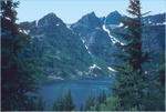
Cabinet Divide
Trail #360
Length: 6.1 miles
South Cabinet Mountains,
about 40 miles south of Libby
Trail Beginning: Road 148
Elevation: 4,360 feet
Trail End: Road 2220
Elevation 5,800 feet |
The Cabinet Divide
Trail offers a variety of hiking opportunities, from short backpacking
trips to rugged day
hikes. Trailhead parking
accommodates 4 cars, but there is limited turnaround space. No stock facilities
are available. |
Travel 28 miles
south of Libby on US 2, then turn right onto the Silver Butte Road 148.
Drive about 14 miles to Silver Butte Pass. Turn right onto the spur road
and follow approximately 1 mile to the signed trailhead. Paved road, then
gravel road access. |
Caribou Trail
#56
Length: 3.0 miles
In the Yaak area
Trail Beginning: Road 5807
Trail End: Caribou |
The trail begins
on a logging road and
runs uphill through a lodgepole
pine stand. Gaining elevation, the trail sidehills around Caribou Mountain
and fades out near the US/Canada border. There are natural clearings and
openings, offering excellent views of the valley and up into Canada and
opportunities to see wildlife. |
From Caribou
Campground, follow the Yaak Highway 92 west .30 mile. Turn and travel Road
5800 to the trailhead. Paved road, then gravel road access. |
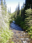
Cedar Creek
Trail #141
Length: 1.3 miles
Appx. 6 miles west of Libby
into the Cabinet Wilderness Area
Trail Beginning: Cedar Creek
Road 402
Trail End: Trail entends
into the Cabinet Mountains Wilderness |
This trail runs
adjacent to Cedar Creek
for its entire length and
enters the Cabinet Mountain Wilderness Area. A lower portion of the trail
was once used as a wagon road for early-day mining. About .8 mile beyond
the trailhead, Scenery Mountain Trail 649 departs to the right. Trail 141
passes Lower Cedar Lake at about 5 miles and reaches Upper Cedar Lake at
the junction. No motorized vehicles are permitted and no vehicles are allowed
within the wilderness boundary. |
From Libby, travel
4.5 miles west on Highway 2. Turn left onto Cedar Creek road and travel
2.5 miles to the trailhead. Parking room is ample. Paved road, then gravel
road access. |
Coyote Ridge
Trail #5.2
Length: 3.0 miles
Southeast of Libby appx
28 miles
Trail Beginning: Tepee Creek
Road 6740
Elevation: 4,400 feet
Trail End: Road 6740
Elevation: 3,600 feet |
This trail offers
an excellent day-hike opportunity. By using two vehicles, and
parking at the lower and
upper access, a one direction (2-4 hours) hike is provided. This trail
provides views of the south central portion of the Cabinet Mountains Wilderness
to the east and Brush Mountain to the northwest. |
From Libby, travel
20.5 miles southeast on Highway 2. Turn left on Tepee Creek Road 6740 and
travel 2.3 miles. The first trail access is on the right; follow Road 6740
another 4.3 miles to the second. Paved road, then gravel road access. |
Divide Trail
#6
Length: 9.0 miles
Appx. 20 miles northeast
of Libby
Trail Beginning: Road 535
Elevation: 3,520 feet
Trail End: Hunter Creek Road
(Plum Creek PVT land
Elevation: 3,320 feet |
This trail offers
several scenic views of the Cabinet Mountains. Used primarily by horsemen,
this trail offers a nice day hike or short backpacking trips No restrooms
or stock facilities are available. |
Travel 12 miles
northeast of Libby on Highway 37. Turn right onto Road 534 and travel 9
miles to the junction with Road 535. Follow 1.5 miles and turn right at
the directions to Divide Trail 6. There is limited parking available at
the gate. Follow the road on foot about 1/25 mile to the signed trailhead |
East Fork
Pipe Creek-Baldy Snowmobile Trail
Length: 15 miles (one way)
Northwest of Libby appx.
18 miles
Trail Beginning: Pipe Creek
Elevation: 3,162 feet
Trail End: Where trail loops
to Big Creek Baldy Lookout
Elevation: 5,768 feet |
This 30-mile
groomed loop trip, which
can include a short side
trip to Big Creek
Baldy Lookout, offers views
of the Yaak and Kootenai River areas. Wood is
scarce, so provide wood
from lower trail if a fire is desired. Watch for ski tourers. |
From Libby, follow
the Pipe Creek road for 18 miles to Junction with East Fork Pipe Creek
Road 336. Park in the plowed area.
Paved road access. |
Fisher Divide
Trail #5.1
Length: 6.5 miles
Appx. 27 miles south of
Libby
Trail Beginning: Tepee Lake
Elevation: 4,200 feet
Trail End: Just below top
of Brush Mountain
Elevation: 5,500 feet |
This trail offers
a nice experience for horseback or mountain bike use, though it is
also a fine hiking experience and is mostly located on or near ridgetops,
offering beautiful views of the Cabinet Mountains. |
From Libby, 20.5
miles southeast on US 2.
Turn left on Tepee Creek
Road 6740 and travel 7.3 miles to Tepee Lake. The trail is signed and takes
off near the eastside of the lake. It begins as an old two-track road.
Paved road, then gravel road access. |
Flagstaff
Mountain Trail #43
Length: 2 miles
Approx. 18 miles northwest
of Libby
Trail Beginning: Road 4690
Elevation: 4,695 feet
Trail End: Flagstaff Mountain
Elevation: 6,075 feet |
The Flagstaff
Mountain Trail offers an excellent, relatively easy hike for the
family. The trail winds through grassy meadows and follows a gentle ridge
to the summit of Flagstaff Mountain. The Selkirk Mountains
of Idaho, the Purcell and Cabinet Mountains of Montana, and the Kootenai
Valley can be seen. No motorized vehicles are allowed. |
From Libby, travel
1/2 mile north on Highway 37, crossing the Kooteani River. Turn left on
River Road and travel 4 miles to Quartz Creek Road 500. Turn and follow
for 5 miles. Turn left on the West Fork Road until it ends at a T junction
just after crossing the West Fork of Quartz Creek. Turn left and follow
to Road 4690, approximately 7.3 miles. Paved road, then gravel road access. |
Flatiron Mountain
Trail
Length: 1.5 miles
Appx. 22 miles northwest
of Libby up Pipe Creek
Trail Beginning: Rainbow
Ridge
Elevation: 4,800 feet
Trail End: Top of Flatiron
Mountain
Elevation: 5,891 feet |
There is no trail
on Flatiron Mountain, but
the open ridge is easy to
follow and offers beautiful views of the Yaak and Kootenai areas. This
is an excellent family trip. |
From Libby, turn
onto the PipeCreek road and travel north 22 miles to the Rainbow Lake road.
Turn left and take the third right, turning at the road forks. Parking
is available at the end of this road. Follow the trail signs. Paved road,
then gravel road access. |
Flower Creek
Trail #137
Length: 6.5 miles
Appx..7 miles south of Libby
Trail Beginning: Parking
area on Road 128
Elevation: 3,700 feet
Trail End: Lower Sky Lake
Elevation: 6,200 feet |
The first 2 miles
the trail are on a south
slope above Flower Creek.
At about 3
miles, it takes off through
a campsite on the left. At about 4.5 miles, Trail 317
forks to the right, towards
the Cabinet Divide trail and Minor Lake. No motorized vehicles are permitted
on this trail, and no vehicles are allowed within the wilderness
boundary. The Flower Creek trailhead also provides access to Indianhead
Trail, Parmenter Creek 140 Cutoff, and the Flower Lake trail. The Flower
Creek road is closed seasonally for wildlife habitat protection, but is
generally open from June through September. |
From Libby, travel
.3 mile south on US 2. Turn on the Golf Course Hill road, turning left
at the 3-way intersection. Follow the Snowshoe road for 1/2 mile and turn
right on Granite Creek road. Travel 1 mile and take Flower Creek Road 128
for 5 miles to the trailhead. Ample parking is provided. Mostly gravel
road access. |
Fourth Of
July Trail #115
Length: 2.3 miles
South of Libby appx 30 miles.
Trail Beginning: Road 2332
Elevation: 3,800 feet
Trail End: Trail 656
Elevation: 5,200 feet |
This trail is
located in lodgepole forest for most of its distance and crosses
the creektwice. The trail gives access to the Geiger Lakes basin. There
is a stock ramp at the trailhead. No motorized vehicles are permitted on
this trail. No vehicles are allowed within the wilderness boundary. |
From Libby, travel
south 24 miles on US 2. Turn right onto West Fisher Road 231 and follow
for approximately 6 miles to the junction with the Lake Creek Road. Turn
left and follow .8 mile to the Lake Creek Campground/Bramlet Lake Junction.
Turn right and travel 1 mile. The trailhead is located on the left as the
road switches back to the right. Paved road, then gravel road access. |
Geiger Lakes
Trail #656
Length: 1.5 miles
Appx. 32 miles south of
Libby, in the Cabinet Wilderness
Trail Beginning: Trailhead
Elevation: 3,666 feet
Trail End: Junction with
Cabinet Divide Trail 360
Elevation: 6,000 feet |
This trail takes
you past Lower and Upper Geiger Lakes. Lower Geiger Lake is reached at
about 2 miles. The trail continues to Trail 48 which leads to Upper Geiger
Lake. Trail 656 climbs and continues to Lost Buck Pass and Trail 360, offering
scenic views including an overlook to the west into Wanless Lake. One campsite
at Lower Geiger Lake is closed and the use of fire is prohibited in the
lower lake basin. No motorized vehicles are permitted on this trail. No
vehicles are allowed within the wilderness boundary. |
From Libby, 24
miles South on US2. Turn right onto West Fisher Road231 and continue for
6 miles. Turn left on the Lake Creek road and after 1/2 mile. Tturn left
again on the Geiger Lakes road and continue 2 miles to the parking area.
The trail leaves the road about 100 feet before the parking area. Paved
road, then gravel road access.
|
Goat Mountain
Trail #148
Length: 1.5 miles
Trail Beginning: Road 4555
Elevation: 3,400 feet
Trail End: Goat Mountain
Elevation: 5,416 feet |
After following
a creek bed for .3 miles, the trail changes to a moderately steep hike.
It follows a sidehill with narrow tread in a few spots. The Cabinet Mountains
can be viewed from the top of Goat Mountain. |
From the junction
of US 2 and Iron-Grouse Road, travel south on Iron-Grouse 4 miles to the
junction with FS Road 4555. Turn and follow to the trailhead. Paved, then
gravel road access. |
Granite Creek
Trail #136
Length: 6.25 miles
Appx. 10 miles south of
Libby, into the Cabinet Wilderness Area
Trail Beginning: End of Road
618
Elevation: 3,200 feet
Trail End: Granite Lake
Elevation: 4,600 feet |
This is an easy
trail throughout most of its length, and continues on into the Cabinet
Mountains Wilderness. Granite Creek falls and campsite are located about
2 miles up the trail in a cedar and hemlock forest. A magnificent view
of A Peak is obtained at Granite Lake. No motorized vehicles are permitted
on this trail, and no vehicles are allowed within the wilderness boundary. |
From Libby, travel
2 miles south on US 2. Turn right onto the Golf Course Hill, then left
at 3-way intersection at the top. Follow the Snowshoe road for 1/2 mile,
then turn onto Granite Creek Road 618. The trailhead is approximately 8
miles down the road. Horse trailer parking is provided .3 mile from the
trailhead. Paved, then gravel road access. |
Grouse Lake
Trail #423
Length: 1.5 miles
Approx. 7 miles south of
Troy
Trail Beginning: Road 473
Trail End: Grouse Lake |
A superb hike
for families, this trail has
only a few steep sections.
It follows a
creek bed most of the way
and has excellent tread throughout. Even though the trail is short and
close to town, the sense of remoteness is outstanding. |
From US 2 near
Troy, take the Lake Creek road south approximately 6.5 miles to the trailhead.
Paved road, then gravel road access. |
Henry Lakes
Trail #7
Length: 3.7 miles
Appx. 60 miles northeast
of
Troy
Trail Beginning: Road 6034
Trail End: Mt. Henry
Elevation: 7,243 feet |
This trail takes
you through the forest to Mt.Henry Lake, which sits at the base of Henry
Mountain. The trail is mostly through trees with occasional glimpses
of the valley. Mt. Henry
Lakes has a dispersed campsite. There is heavy timber on the trail side
of the small lake, and talus rock on the back side. |
From Troy, drive
northeast 59 miles on FDR 92. Turn south on Road 6035 and follow it for
approximately 2.5 miles to the junction with Road 6034. Turn and follow
this road for about 4 miles to the end of the road and the trailhead. Paved
road, then gravel road access. |
Himes Spring
Creek Trail #343
Length: 2.2 miles
South of Libby appx. 40
miles
Trail Beginning: Trail 293
Elevation: 3,380 feet
Trail End: Blacktail Peak
Elevation: 4,400 feet |
The trail climbs
steeply for its entire length and is suitable for rugged day hikes or short
backpacking trips. There is adequate parking at the Waloven-Himes trailhead
for 2 vehicles, but turn-around space is limited. No restrooms or stock
facilities are available. |
Drive 28 miles
south Libby on US 2. Turn right onto Silver Butte Road 148 and travel 3.5
miles to East Fisher Road 154. Proceed 4.3 miles to Waloven-Himes Trailhead
293, then 3 miles to the signed junction with Himes Spring Creek Trail
343. Paved road, then gravel road access. |
Horse Mountain-Libby
Divide Trail #716
Length: 6.25 miles
South of Libby appx. 30
miles
Trail Beginning: Ridge dividing
Howard Creek and Miller Creek
Elevation: 4,450 feet
Trail End: Horse Mountain
Elevation: 5,200 feet |
This trail offers
a ridgetop hiking experience with many scenic vistas along the way. The
trail is gentle except for the first and last .5 mile stretches. For more
information on this trail, see Miller Creek - Libby Divide and Swamp Creek
- Libby Divide |
From Libby, drive
25 miles south on US, then turn right on Miller Creek Road 385. Follow
for 2 miles. Turn left, crossing Miller Creek, and travel 5 miles. Turn
right at the first road junction, then left at the second junction. The
trail is on the right and is signed. Paved road, then gravel access |
Hoskins Lake
Trail #162
Length: 1.9 miles
North of Libby
Trail Beginning: Road 746
Elevation: 3,240 feet
Trail End: Road 746
Elevation: 3,160 feet |
This trail offers
hikers and fishermen easy access to fishing at Hoskins Lake. Camping
areas are available within 100 yards of the water at either end of the
lake, and a path provides good access to the west side. There is no developed
drinking water. |
Turn north on
Venal Lake Road 746 from South Fork Pipe Creek Road 68 and travel 7.3 miles
north. Parking is available for 3 vehicles at the trailhead. Paved road,
then gravel road access. |
Kenelty Mountain
Lookout Trail #104
Length: 2.5 miles
South of Libby appx 36 miles,
north of the Historic Raven Ranger Station
Trail Beginning: Road 761
Elevation: 4,520 feet
Trail End: Junction Trail
6
Elevation: 5,760 feet |
This is a ridgetop
trail that junctions with
Divide Trail 6, providing
scenic views of the Cabinet Mountains. This trail is used primarily by
horsemen but is good for an average day hike and short backpacking trips.
No restrooms or stock facilities are available. |
From Libby, drive
south 33 miles on US 2. Turn left onto Road 761 just past the Historic
Raven Ranger Station. Travel approximately 3 miles, then turn right onto
an unnumbered spur road and drive to the end. Paved road most of the way,
then gravel/dirt road access. |
Kootenai Creek
Trail #218
Length: 2.5 miles
Near Kooteani Falls, between
Libby & Troy
Trail Beginning: US 2, N
of Kootenai Falls footbridge
Elevation: 1,160 feet
Trail End: Forest Service
Road 4445
Elevation: 4,180 feet |
After crossing
the Swinging Bridge, this
trail follows Kootenai Creek
up and around the open faces above Kootenai Falls before tieing into Kootenai
Mountain road. A rather steep trail, it offers excellent views of the river
and falls. Opportunities for viewing bighorn sheep and wildlife are plentiful. |
From Troy, E
6 miles on US Highway 2. Paved highway access. |
Leigh Lake
Trail #132
Length: 1.5 miles
In the Cabinet Wilderness,
approx. 15 miles southwest of Libby
Trail Beginning: End of Road
4786
Elevation: 4,200 feet
Trail End: Leigh Lake
Elevation: 5,200 feet |
This is a short,
steep trail that is heavily used as an access point into the Cabinet
Mountains Wilderness. Mountain
goats
are often seen on the slopes
above Leigh
lake. No camping is allowed
within 300
feet of the lake. No motorized
vehicles are permitted on this trail, and no vehicles are allowed within
the wilderness boundary. |
From Libby, drive
7 miles south on US 2. Turn right on the Bear Creek Road and travel 3 miles
to Cherry Creek Road 867. Turn right and follow for approximately 4 miles.
Turn right on Leigh Creek Road 4786 and follow 2 miles to the trailhead. |
Little Spar
Lake Trail #143
Length: 3.0 miles
Apprx. 4 miles west of Bull
Lake, 15 miles south of Troy
Trail Beginning: Road 384
Elevation: 3,610 feet
Trail End: Little Spar Lake
Elevation: 5,200 feet |
This trail is
only open for a short period of time during the summer months. The area
is showing signs of impacts from campers, so the Forest Service requests
visitors use low impact camping away from the lake. Just beyond Spar Creek,
the cliffs and pinnacles of Spar Peak are visible from the trail, which
remains on a sidehill most of the way. It follows the creek up a steep
narrow valley with avalanche chutes and steep rock walls where mountain
goats may occasionally be viewed. Due to heavy snows and high water flows
in the creek, this trail is only open for a short period of time in the
summer months. |
From Junction
of US 2, take the Bull Lake Road south appx 10 miles to Road 384. Follow
signs to the Spar Lake Road and to the trailhead and parking area. Paved
road, then gravel road access. |
Miller Ridge
Trail #506
Length: 4.5 miles
South of Libby approx. 27
miles with views of the Cabinets.
Trail Beginning: Road 385
Elevation: 3,400 feet
Trail End: Junction with
Horse Mountain/Libby Divide Trail |
This trail offers
outstanding views of the Cabinet Mountains to the west and Teeters Peak
to the south. The trail starts on a fairly steep south slop, then switchbacks
up to a more gentle ridgetop area, then climbs to the Libby Divide Trail.
This trail is a nice ridgetop hiking or stock use experience. |
From Libby, travel
25 miles south on US 2. Turn right onto Miller Creek Road 385 and travel
approximately 2 miles. The trailhead is signed on the right side of the
road junction. Highway, then gravel road access. |
Noisy Creek
Trail #263
Length: 4 miles
North of Libby appx 13 miles
up Pipe Creek Rd
Trail Beginning: Road 68
Elevation: 2,900 feet
Trail End: Ridge south of
Gold Hill
Elevation: 4,800 feet |
This trail is
lightly used and accesses remote unroaded country, making it an excellent
trip for those seeking solitude. There is a good campsite at the trail's
end. |
From Libby, travel
across the bridge over the Kootenai River and drive 1/2 mile north on Highway
37. Turn left onto Pipe Creek Road 68 and follow for it for about 13 miles.
The signed trail is on the right, approximately .3 mile north of Carrie
Creek. Paved road, then gravel/dirt road access. |
Northwest
Peak Trail #169
Length: 2.3 miles
In the Yaak
Trail Beginning: Forest Road
538
Elevation: 6,200 feet
Trail End: Northwest Peak
Elevation: 7,705 feet |
This trail offers
a nice hiking experience in the forest. The lower half of the trail is
the easiest climb, with an average grade of 10 percent. The climb to the
top of Northwest Peak has grades from 10 to
35 percent. Drinking water
is not available enroute. The trail is closed to motorized travel from
April 1 to November 30. |
From Troy, travel
west 10 miles on US 2. Turn north onto Highway 508/Yaak Road 92 and follow
to Pete Creek Road 338, approximately 20+ miles. Turn northwest and follow
approximately 22 miles to the trailhead. Parking is available for 2 vehicles.
Paved road, then gravel road access. |
Old Highway
#2 Trail, Hiking & Biking
Length: 2 miles
Appx. 5 miles southeast
of Troy on Bull Lake Rd, Hwy 56, near Shannon Lake junction
Trail Beginning: Shannon
Lake road parking area
Elevation: 2,320 feet
Trail End: Picnic area
Elevation: 2,180 feet |
This trail is
part of the old windy highway from Libby to Troy. It is an easy hike and
offers spectacular views of the Kootenai River. Although an old dirt road
that is now overgrown with softwoods and wildflowers, the path may be easily
followed. |
From Troy, travel
south 3 miles on US 2 to the junction of Montana 56 (Bull Lake Rd) and
follow for approximately 2 miles to the Shannon Lake junction. Turn and
follow .3 mile to the parking area. Directional signs lead to the trailhead.
Paved road access. |
Olson Creek
Trail #415
Length: 3.5 miles
South of Libby appx 35 miles
off the Silver Butte Rd.
Trail Beginning: Road 148
Elevation: 3,380 feet
Trail End: Trail 6
Elevation: 4,400 feet |
This trail offers
opportunities for average day hikes and short backpacking trips. Parking
is limited to turnouts, located within 1/2 mile above and below the trailhead.
No stock facilities or restrooms are available. |
From Libby, travel
south 28 miles on US 2. Turn right onto Silver Butte Road 148 and travel
approximately 7 miles to Olsen Creek. The trailhead is signed. Paved road,
then gravel road access. |
Parmenter
Creek Trail #140
Length: 8.5 miles
Trail Beginning: Parmenter
Hill Road
Elevation: 2,400 feet
Trail End: Junction of Trails
141 and 360 at Upper Cedar Lake
Elevation: 5,900 feet |
This trail is
accessed near the town of Libby and can take you to Minor Lake, Parmenter
Pass, and Upper Cedar Lake in the Cabinet Wilderness area. At 2 miles,
this trail meets Trail 15 and continues to the right for 4 miles to the
junction with Trail 317 to Minor Lake. Trail 140 continues to the right
and climbs steeply to the North Fork of Parmenter Pass, gaining 2,200 feet
in just over 2 miles. The trail then drops into Upper Cedar Lake. No motorized
vehicles are permitted on this trail, and no vehicles are allowed within
the wilderness boundary. |
From Highways
2 and 37 in the town of Libby, go west 1 block. Turn left on Main Street
and follow to Balsam. Turn right and cross Flower Creek bridge. Turn left
and drive .4 mile, turning right up Parmenter Hill. At top of hill take
the first right and follow the main road to a Y. Take the unpaved left
fork about 200 yards to the trailhead sign. Paved road access. |
Pete Creek
Snowmobile
Length: 18.0 miles
The Yaak, approx. 55 miles
from Troy
Trail Beginning: 36 miles
North Troy
Elevation: 3,000 feet on
FDR 92
Trail End: Extends up to
Northwest Peaks Scenic Area
Elevation: 6,500 feet |
This is an intermittently
groomed snowmachine trail that offers many open areas and excellent views
of the Canadian Rockies and Northwest Peaks, which border Idaho. The trail
follows Pete Creek and crosses the West Fork of the Yaak River. Intermittently
groomed by the State of Montana and Lincoln County Sno-Kats Snowmobile
Club, this route is a good run and accesses numerous play areas. Weather
changes rapidly in this area; be prepared. |
From Troy, drive
northeast 36 miles on FDR 92 to Road 338. Plowed parking is available at
the turnoff. Follow to the Hawkins Lake area, approximately 18 miles. Paved,
then gravel road access. |
Pulpit Mountain
NRT #366
Length: 5.0 miles
Northeast of Troy appx.
15 miles
Trail Beginning: Road 4439/4441
Elevation: 4,680 feet
Trail End: Road 331
Elevation: 2920 feet |
NATIONAL RECREATION
TRAIL
This is an easy hike from
Pulpit Mountain down the ridgeline to Rabbit Creek. The trail offers nice
views all along it. Below Pulpit Mountain, the trail becomes a bit unclear,
but can be found easily if you follow the ridgeline. |
From the junction
of Kootenai River Road and Road 331, just east of Troy, follow Road 331
to the Lynx Creek Road. Turn and travel .6 mile to Road 4433, turn and
follow for .8 mile. Turn left onto Road 4439 and follow for 1 mile to Road
4441. The trailhead is approximately 2 miles north of the junction The
final 3.5 miles are rough and not suitable for sedans. Gravel and dirt
road access. |
Purcell Mountains
Snowmobile
Length: 70 miles
Elevation: 4200 feet |
There is usually
enough snowfall in this area by Thanksgiving to enjoy snowmobiling, often
through April. Snowmobilers share this area with cross-country skiers who
also like the easy grades and scenery, so caution is urged. There are many
secondary roads to explore that go off from this main route. The trip to
the reservoir is a long, very scenic ride. The nearest plowed access to
the far end is at Koocanusa Bridge, another 9 miles. There are approximately
70 miles of groomed snowmobile routes in this area. |
From Libby, cross
the bridge over the Kootenai River on Hwy 37 and go1/2 mile north to Pipe
Creek Road 68. Turn left and follow 19 miles to the trailhead which is
immediately adjacent to the road. Paved road access. |
Purcell Trail
#7
Length: 7 miles
North of Libby appx 25 miles
on Pipe Creek Road
Trail Beginning: Road 4216D
Elevation: 5,200 feet
Trail End: Zulu Creek trail
junction
Elevation: 6,200 feet
|
This trail was
reopened in 1986 after being abandoned in the 1940's. It receives very
light use and provides an excellent horseback opportunity. |
From Libby, cross
the bridge over the Kootenai River and drive north 1/2 mile on Highway
37. Turn left on Pipe Creek Road 68 and travel 19 miles to a 3-way junction.
Go straight for 1/2 mile on Road 112. Follow Road 6783 when it switches
back to the left and travel 4.3 miles to Road 4716. Turn left and follow
2 miles, then right on Road 4716 for 1/2 mile. Paved road access, then
gravel. |
Ross Creek
Trail #142
Length: 4.5 miles
Ross Creek Scenic area,
21 miles south of Troy
Trail Beginning: Ross Creek
Scenic Area at end of Road 398
Trail End: Sawtooth Mountain;
access to Scotchman Peaks area |
This trail follows
Ross Creek the entire distance, and is an excellent day hike through a
closed canopy of cedar and hemlock trees. Enjoy the sounds and smells of
the forest as you hike along this trail. During high runoff fording the
creek may be difficult, so caution should be exercised. |
South of Troy
approximately 21 miles on Montana 56, then West 4 miles on Road 398. |
Scenery Mountain
Lookout Trail #649
Length: 5.0 miles
Northern end of the Cabinet
Mtn Wilderness area, 7 miles west of Libby
Trail Beginning: Trail 141
Elevation: 2,800 feet
Trail End: Scenery Mountain
Lookout
Elevation: 6,876 feet |
Scenery Mountain
Lookout is located in the northern end of the Cabinet Mountain Wilderness
Area and has a commanding view of the Kooteanai River Valley and Libby
area. The first section of this trail is the easiest and follows Cedar
Creek for approximately .8 mile. The tail then climbs and becomes more
difficult after reaching the junction. Trail 319 traverses the ridge to
the west to Grambauer Mountain. The lookout is manned seasonally from June
15 to September 15. Located within the wilderness area, no motorized vehicles
are permitted on this trail, and no vehicles are allowed within the wilderness
boundary. |
From Libby, go
west 4.5 miles on US 2. Turn left onto Cedar Creek Road 402 and follow
2.5 miles to Cedar Creek Trail 141, which provides access to the Scenery
Mountain Trail. Ample parking and stock loading ramp are provided. Paved
road acceess. |
Shafer Creek
Trail #226
Length: 6.5 miles
Northwest of Libby appx.
14 miles up Pipe Creek Rd. Big Creek Baldy Lookout area.
Trail Beginning: Road 68
Elevation: 2,950 feet
Trail End: Big Creek Baldy
Lookout
Elevation: 5,768 feet |
The upper portion
of this trail is used by people renting the Big Creek Baldy Lookout. This
trail offers a good opportunity for the day hiker or horseback riders.
The bottom 4 miles goes through areas with tree snags that are home to
bird species such as the pileated woodpecker and several types of owls.
The upper stretch follows old clearcuts and natural openings and is marked
with rock cairns (rock stacks) to show the way. |
From Libby, travel
across the Kootenai River bridge north 1/2 mile on Highway 37. Turn left
onto Pipe Creek Road 68 and follow it for 14 miles to the trailhead, which
will be on the right. Paved road access. |
Silver Butte
Creek Trail #296
Length: 3.4 miles
Approx. 38 miles south of
Libby on the Silver Butte Rd, south Cabinet Mountains
Trail Beginning: Road 148
Elevation: 4,000 feet
Trail End: Sec.13. T25N R31W,
Trail 360
Elevation: 6,240 feet |
The Silver Butte
Creek Trail has pretty views of Silver Butte, the Vermillion River and
Noxon Reservoir areas. This trail makes a nice rugged day hikes or short
or extended backpacking trips. Trail 296 passes a shallow, unnamed lake
3 miles from the trailhead. There is adequate parking at the trailhead
for 3 vehicles. No restrooms or stock facilities are available. |
Travel 28 miles
south Libby on US 2. Turn right on Silver Butte Road 148 and proceed for
10 miles to Powerline Road 2220. Turn right and travel 1 mile to the signed
trailhead. Paved road and then gravel road access. |
Skyline NRT
#13
Length: 10.0 miles
Northwest of Libby appx.
13 miles
Trail Beginning: C Spur of
Road 4654
Elevation: 5,200 feet
Trail End: Just west of O'Brien
Mountain
Elevation: 6772 feet
(trail continues to Three
Rivers Ranger District and ends approximately 2.5 miles above Yaak Falls) |
NATIONAL RECREATION
TRAIL
The Skyline Trail System
is part of the National Recreation Trail System and offers hikers
or horsemen an excellent opportunity to view wildlife and see pretty country.
The trail length and numerous camping spots make this an ideal 2-day hike. |
From Libby, travel
over the bridge across the Kootenai River north for 1/2 mile on Highway
37. Turn left onto River Road shortly after crossing the bridge and travel
4 miles. Turn right onto Quartz Creek Road 600 and follow it for 5 miles.
After crossing the bridge, turn right onto Ransome Creek Road 4654. Follow
this road for 7 miles, turn onto the C spur, and follow for 1/2 mile. Paved
road, then gravel road access. |
South Fork
Callahan Trail #154
Length: 3.5 miles
Approximately 10 miles from
Troy
Trail Beginning: Road 4541
Trail End: Lake Darling |
This trail follows
South Fork of Callahan Creek and passes through old growth timber stands
as well as open areas where the Smith Mountain fire burned down to the
creek. Remnants of an old log chute used to send logs down the valley to
Troy are still visible. |
On the outskirts
of Troy's city limits, follow Callahan Creek Road 414 approximately 10
miles to the junction with Road 4541 and the trailhead. |
South Fork
Ross Creek Trail #321
Length: 2.0 miles
Ross Creek Cedars Grove
area
Trail Beginning: Trail 142
Trail End: Junction Trail
321 and Trail 142 |
This trail follows
Ross Creek the entire way. The trail begins about 2 miles along the Nature
Trail through the Scenic Area. Begin this hike by fording Ross Creek. Trail
321 is overgrown and somewhat difficult to find, but once located, the
trail is easy to follow to a waterfall and potential campsite. The side
slope is eroded in a few places and should be hiked with caution. |
From Hwy 2 near
Troy, take the Bull Lake Road south to the junction of Montana 56 and Road
398. Follow Road 398 to the Ross Creek Scenic Area. Follow the nature trail
to Trail 142. The South Fork trail intersects Trail 142 approximately 2
miles from this junction. Paved road access the entire way. The road from
the highway up to Ross Creek Scenic Area is narrow and windy with hikers
and bike riders often on the road. Use caution. |
Spar Peak
Trail #324
Length: 3.2 miles
Spar Lake is west of Bull
Lake appx.4 miles
Trail Beginning: Road 384
Elevation: 3,600 feet
Trail End: Spar Peak
Elevation: 6,585 feet |
This trail is
steep, but the view from the top is worth it. The trail goes through open
meadows and old stands of hemlock and cedar trees. The ascent to the top
will give you a workout. Use caution during wet weather as a portion of
the trail has slick and rocky tread. |
From Hwy 2 near
Troy, take the Lake Creek road turn and follow to Spar Lake. The trailhead
is approximately 22 miles from the highway. All junctions are marked. Paved
road, then gravel road access. |
Standard Creek
Trail #116
Length: 5.25 miles
South of Libby about 34
miles
Trail Beginning: Gate on
Road 6745
Elevation: 3,500 feet
Trail End: Just south from
top of Great Northern Mountain
Elevation: 6,500 feet |
This trail climbs
gently for the first mile, then climbs steeply. The end of the trail provides
spectacular views of Upper Libby Creek, Elephant Peak, and the south Cabinet
Mountains Wilderness. This is an excellent horseback trail and also
makes a good overnight hike. |
From Libby, go
south 25 miles on US 2. Turn right on Libby Creek/Fisher River Road 231
and follow it for 7 miles. Turn left on Standard Creek Road 6745 and travel
1.5 miles to the trailhead. Paved road, then gravel road access. |
Teeters Peak
Trail #300
Length: 2.6 miles
South of Libby appx. 32
miles with views of the southern Cabinet Mountains
Trail Beginning: Road 4724
Elevation: 4,420 feet
Trail End: Teeters Peak summit
Elevation: 5,230 feet |
Views of the
central and southern portions of the Cabinet Mountain Wilderness area are
what makes this trail special. It offers a relatively easy 3 to 5-hour
hike, but isn't particularly good for overnight camping or horseback use
due to its short length and lack of water. |
From Libby, travel
south 25 miles on US 2. Turn right on Miller Creek Road 385 and follow
it for 2 miles. Turn left and stay to the right. The trailhead is 5.3 miles
from the creek crossing, and begins on the left side of the road. Paved
road, then gravel. |
Tepee Mountain
Trail #710
Length: 6.0 miles
Northwest of Troy appx.
10 miles
Trail Beginning: 5 miles
from Road 2351 and MT 92
Trail End: 1 mile East of
Newton Mountain |
The Tepee Mountain
Trail offers ridgetop hiking with scenic views of the surrounding
countryside. During the early months wildflowers are abundant. There is
little or no water on the trail during the summer months. |
From Troy, travel
west 8 miles on US 2. Turn onto Montana 508/Yaak 92 and follow it for 5.5
miles to the junction with Teepee Mountain Road 2351. Turn here and follow
it approximately 5 miles to the trailhead. Paved road, then gravel. |
Upper Pipe
Creek
Length: 4.0 miles
Appx 18 miles north of Libby
on Pipe Creek Rd
Trail Beginning: Road 68
Elevation: 3,115 feet
Trail End: Junction with
Shafer Creek Trail 226
Elevation: 4,100 feet |
The Upper Pipe
Creek Trail offers pretty views of Tom Poole Lake and Shafer Creek in the
Pipe Creek drainage. This trail starts out steeply but becomes more gentle
as it contours the slope. Tom Poole Lake is visible below and to the south.
Two miles up the trail and to the south there is a small unnamed pond.
The trail crosses Shafer Creek about 1/2 mile before the trail's end at
Shafer Creek. Motorized vehicles are not allowed. |
From Libby, cross
the Kootenai River bridge and travel 1/2 mile north on Highway 37. Turn
left onto Pipe Creek Road 68 and travel 17.5 miles to the trailhead. Paved
road access.
|
Vinal-Mt.
Henry-Boulder NRT #9
Length: 8.0 miles
In the Yaak off Pipe Creek
Rd.
Trail Beginning: Road 746
Trail End: Mount Henry Lookout |
NATIONAL RECREATION
TRAIL
This trail gains little
in elevation, therefore making it a great trail for families and less ardent
hikers. The easiest section is where it parallels Vinal Creek on the west
end. As the grade increases, it traverses the ridge to Mt. Henry. Turner
Creek Falls is located near the junction of Turner and Vinal Creeks, and
further on is a panoramic view from atop the mountain. The undeveloped
area provides a near-wilderness experience for an overnight trip with access
to Fish Lakes. |
From Libby, take
the Pipe Creek Rodd over the divide into the Yaak. About 8 miles down the
other side turn right at the junction with South Fork Pipe Creek Road 68
and Venal Lake Road 746. Travel north 6 miles. The trailhead is 100 yards
north of Venal Creek. Paved road, then gravel road access. |