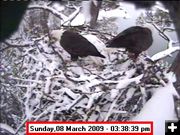

Snow Eagles
Brrrr! View of the bald eagle nest on Sunday, March 8, 2009.
|
|
Winter Weather returns
by National Weather Service
March 8, 2009
A cold Pacific low pressure trough will continue its presence over the northern Rockies Sunday and Monday. A moist and unstable air mass will remain through Sunday and will help maintain snow showers. Cooling aloft will enhance the instability of the air mass bringing the potential for moderate to strong snow showers through Sunday evening.
In addition to snow, Arctic air poised east of the Continental Divide will surge across the Divide starting late Sunday evening. This air will be ushered in by strong east to northeast winds. This combination of very cold air and wind will create sub-zero wind chill values through the travel corridors of the Divide and those western mountain valleys that are typically impacted by Arctic intrusions. Sub-zero wind chills are expected through early Monday.
A Winter Weather Advisory remains in effect until 6 pm Sunday evening. Total snow accumulations of 2 to 6 inches are expected with greater amounts in the higher terrain and over mountain passes by Sunday evening. Brief heavy snow showers could cause reduced visibilities and poor driving conditions at times through Sunday. A Winter Weather Advisory means that periods of snow and blowing snow will cause travel difficulties. Be prepared for slippery roads and limited visibilities, and use caution while driving.
|
