
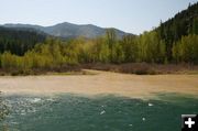
Fisher River high water
The muddy water from the Fisher River enters the Kootenai River east of Libby. View from Friday, May 16th. Photo by Maggie Craig, LibbyMT.com
|
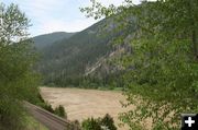
Kootenai River on May 19
The Kootenai River is shown here between Libby and Troy on Monday, May 19. The river is running high and muddy due to runoff from area streams and rivers. Photo by Maggie Craig, LibbyMT.com
|
|
Flood Warnings remains in effect for some area rivers
Yaak River near Troy and Thompson River near Thompson Falls; Warning cancelled for Fisher River near Libby
by Dawn Ballou, LibbyMT.com
May 21, 2008
The Flood Warning for the Fisher River near Libby has been cancelled, according to the National Weather Service out of Missoula. Flood stage for the Fisher River is 7.5 feet. As of 8:00 AM Wednesday morning the stage was 7.2 feet. The river fell below flood stage early on the afternoon of Tuesday, May 20. The river is steady at this time.
The National Weather Service continues their Flood Warnings for the following rivers:
Thompson River near Thompson Falls: The flood warning continues for the Thompson River near Thompson Falls until this afternoon. At 2:00 am Wednesday the stage was 7.1 feet. Flood stage is 7.0 feet. Minor flooding is occurring and minor flooding is forecasted at 7.0 feet. Flooding affects low lying areas adjacent to the river. Flooding also affects homes in the community of Snider. The forecasted stage of 7.1 feet compares to a previous stage of 8.4 feet that occurred on May 17, 1997.
Fisher River near Libby: The Flood Warning continues for the Fisher River near Libby from this morning until after midnight tomorrow. At 4:00 am Wednesday the stage was 7.2 feet. Flood stage is 7.5 feet. Minor flooding is forecasted. The river is steady at this time. However, this river is forecasted to rise above flood stage this morning and is expected to crest at 7.7 ft this afternoon. At 7.5 feet flooding affects low-lying areas adjacent to the river. Flooding also causes minor washouts along Fisher River Road. The forecasted stage of 7.7 feet compares to a previous stage of 8.5 feet that occurred on April 15, 2002.
Yaak River near Troy: The flood warning continues for the Yaak River near Troy until tomorrow early afternoon. At 2:00 am Wednesday the stage was 8.6 feet. Flood stage is 8.0 feet. Minor flooding is occurring and minor flooding is forecasted. At 8.5 feet flooding affects low-lying areas adjacent to the river including homes and access roads. Sylvanite Ranger Station Road and Upper Ford Road affected by flooding. The forecasted stage of 8.4 feet compares to a previous stage of 8.6 feet that occurred on April 15, 2002.
Other Rivers: Other rivers with Flood Warnings include the Flathead River at Columbia Falls, the Middle Fork of the Flathead River near West Glacier, the Middle Fork of the Flathead River near Essex, St. Regis River at St. Regis, Clearwater River at Orofino, Bitterroot River near Missoula, Bitterroot River near Victor, Bitterroot River near Darby, Clark Fork River above Missoula.
More information is available by listening to the NOAA Weather radio or local TV and radio stations. Current information and maps are also available at the NOAA website shown below.
|