
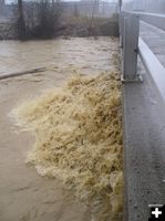
Libby Creek
Water from Libby Creek splashes against a bridge abutment near Libby on Tuesday. The splash was nearly level with the bridge. The National Weather Service has issued a Flood Watch for many streams and tributaries in several northwest Montana counties due to recent heavy rains. Photo by Maggie Craig, LibbyMT.com.
|
|
Rivers and streams nearing flood stage
November 7, 2006
(Libby) - 11/7/06, 1:00 PM Flood Warning Update: Widespread small stream and urban flooding is being reported in the Libby area, according to reports from the National Weather Service early Tuesday afternoon.
Bridges are reported as being washed out, along with water covering roadways due to recent rains.
The Fisher River is rising rapidly and was reported to be 1-1/2 foot from flood stage at 12:15 pm Tuesday.
The National Weather Service out of Missoula has put out a Small Stream Flood Advisory until 10:00 am Wednesday morning for Lincoln, Sanders and eastern Flathead counties g in northwest Montana. Several streams and small tributaries are out of their banks due to recent rains.
Lake Creek in Lincoln County was reported at bankfull on Tuesday. Streams and small tributaries are out of their banks in the Bull River Valley.
Glacier National Park headquarters has reported the Middle Fork of the Flathead River is full, backing up into McDonald Creek near Quarter Circle Bridge. Avalanche Creek was reported to be 2-3 feet out of its bank, forcing closure of the Going to the Sun Road at the Lake McDonald Lodge due to water covering the road. Horse Bridge is reportedly washed out from flood waters. The North Fork of the Flathead River near Polebridge is rising rapidly and is three feet from flood stage.
Rain, locally heavy, will continue across northwest Montana through Tuesday night producing possible additional small stream flooding. Rainfall and runoff could trigger rock slides and debris flows along and near steep terrain and onto area highways.
The National Weather Service cautions drivers not to drive vehicles into areas where water covers the roadway. The water depth may be too great to allow the vehicle to cross safely. Those in low-lying areas near flooding areas should move to higher ground.
Related Links:
National Weather Service, www.weather.gov
|