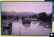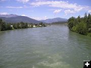
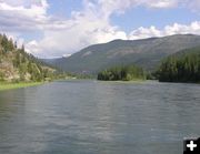
River near Libby
View of the Kootenai River high flows, looking west (downstream) from the old haul bridge on Monday, June 19, 2006. Downtown Libby is just to the left. Photo by Maggie Craig.
|
Full Pool
The lake water level was .03 feet below full pool on Monday, June 19, 2006. Inflow was 900 cfs higher than discharge. Photo by Maggie Craig.
|
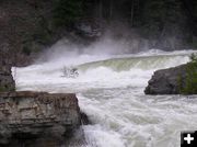
Where are the falls?
Kootenai Falls are all but submerged under the current high flows. Photo taken on Saturday, June 17. Photo by Maggie Craig.
|
Low Flow View-2003
Same view of the falls as the previous photo, this one was taken in September, 2003. Photo by Maggie Craig.
|
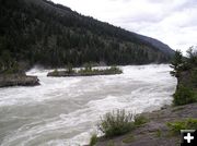
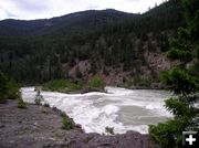
High flows-June 2006
Flows on this date (Saturday, June 17)are now discharged from Libby Dam at 55,000 cubic feet per second. This is a photo at Kootenai Falls of the side channel to the left of the main falls. Photo by Maggie Craig.
|
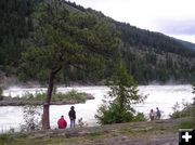
Watching the river wild
The river is an incredible sight with the extremely high flows. This view is at Kootenai Falls, taken on Saturday, June 17. Photo by Maggie Craig.
|
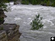
Kootenai River high flows
This cottonwood tree is submerged in the high water just below Kootenai Falls. Photo taken on Saturday, June 17. Photo by Maggie Craig.
|
Falls under water-June 2006
Another view of the Kootenai Falls area with the high flows of the Kootenai River on Saturday, June 17. Photo by Maggie Craig.
|
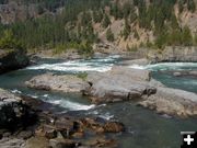
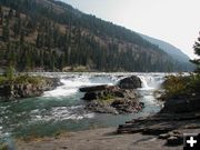
Downstream view-2003
View of Kootenai River in September, 2003 showing roughly the same place as previous photo. Photo by Maggie Craig.
|
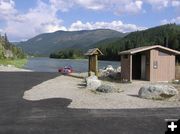
Osprey Landing 2006
Osprey Landing boat launch site on Monday, June 19. Photo by Maggie Craig.
|
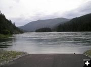
Osprey Landing 2005
Osprey Landing view of the Kootenai River with normal flows in August, 2005. Photo by Dawn Ballou.
|
Osprey Landing high flows
Osprey Landing high flows on Monday, June 19, 2006. Photo by Maggie Craig.
|
Osprey Boat Launch 2005
Osprey Landing Boat Launch a year earlier in August, 2005, as a comparison picture. Photo by Dawn Ballou.
|
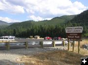
Osprey Landing Boat Launch
Osprey Landing Boat Launch site on the Kootenai River at the location of the old rereg dam site, halfway between Libby and Libby Dam. Archive photo from 2005 by Dawn Ballou.
|
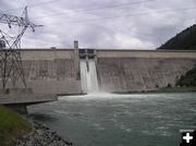
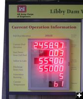
Libby Dam-June 2006
Libby Dam on Monday, June 19, 2006. The flow discharge through the dam spillways is between 55,000-56,000 cubic feet per second (cfs). Rainstorms in Canada were causing inflow to Lake Koocanusa Reservoir to reach a high of 64,000 cfs. The lake water level behind the dam is nearly at full pool on this date (Monday). Photo by Maggie Craig.
|
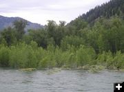
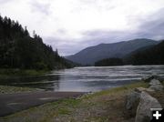
Flooded Riverbank
Near the confluence of the Fisher and Kootenai Rivers, a couple miles downstream from Libby Dam, on Monday, June 19, 2006. Photo by Maggie Craig.
|
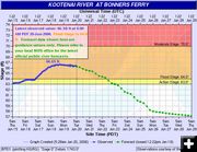
River Flow Level Graph
Kootenai River water flow levels are above flood stage at Bonners Ferry, Idaho. Graph by the National Weather Service Advanced Hydrologic Prediction Service. Idaho Governor Jim Risch declared a state of emergency on Friday, June 16, because of high water levels on the Kootenai River.
|
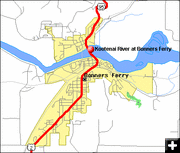
River at Bonners Ferry Idaho
High flow releases from the Libby Dam have caused the Kootenai River to crest at 66.63 feet on Sunday, June 18, in Bonners Ferry, Idaho. Flood stage at this location is 64 feet. Because Libby Dam managers must leave the discharge high to release the high flow volumes coming into Lake Koocanusa, they will continue to have these high flows at least through Thursday, June 22. The high water has flooded the city park and threatens the Kootenai River Inn, which is being sandbagged. There were no reported injuries or structural damage as a result of the high water as of Sunday, June 18 in Bonners Ferry. National Weather Service map.
|
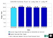
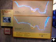
Flood Tracking
Graph showing historical flood stages at Libby Dam. USGS chart.
|
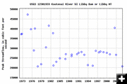
Historical Peaks
Historical peak flows at Libby Dam. USGS graphic.
|
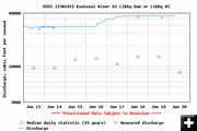
June 2006 Discharge
Kootenai River discharges below Libby Dam for June 13-20, 2006. USGS graphic.
|
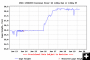
River Gauge Height
Kootenai River gauge height measurements below Libby Dam for June 13-20, 2006. USGS graphic.
|
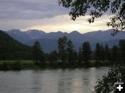
River on June 9, 2006
The Kootenai River on Friday, June 9, 2006. Photo by Maggie Craig.
|
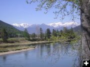
River on April 29, 2006
Kootenai River on April 29, 2006. Photo by Maggie Craig.
|